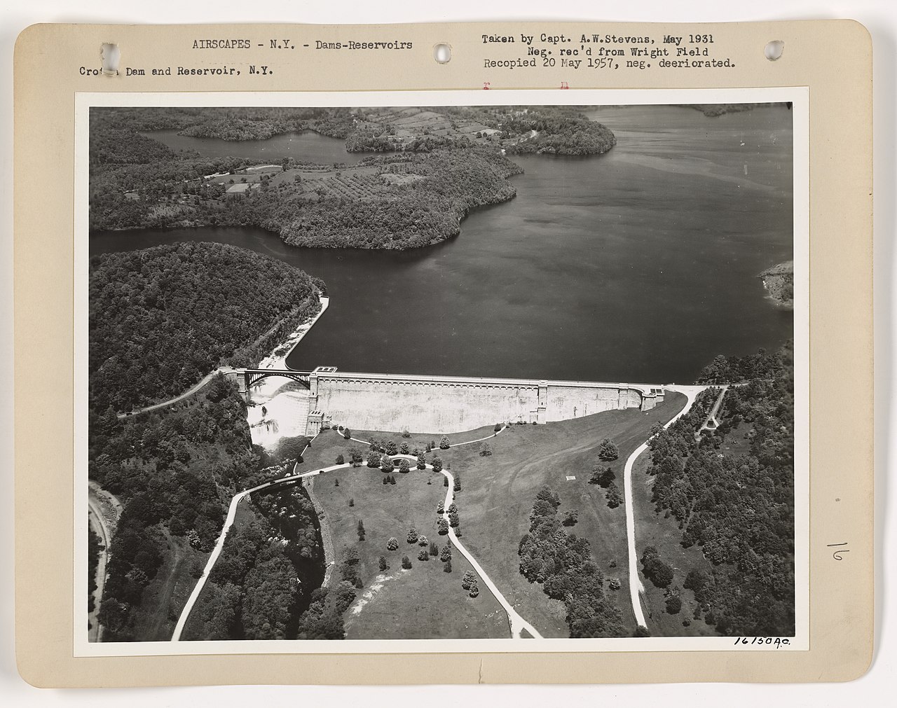
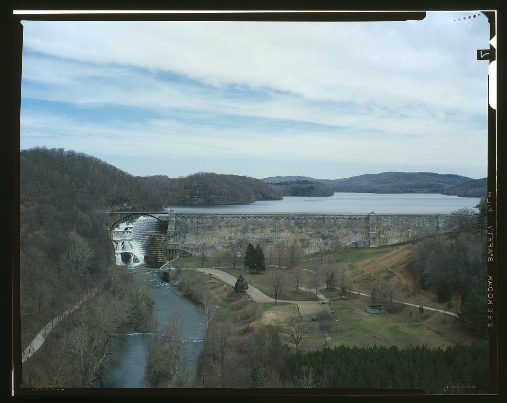
Drive north on Route 129 out of Croton-on-Hudson and the road climbs through hardwood forest, rounds a bend, and suddenly everything opens up. On your left, the Croton River rushes through a gorge that looks geological — the kind of place where you expect to see a waterfall in the distance. And then you do see a waterfall, but it is not geological. It is 266 feet of hand-hewn stone, arranged in a 1,000-foot arc, holding back twenty square miles of water.
This is Croton Gorge Park. 97 acres of picnic grounds, baseball fields, and fishing access at the base of the New Croton Dam — officially also called the Cornell Dam by Westchester County Parks — the third-largest hand-hewn stone structure in the world, after the Great Pyramid of Giza and the Great Wall of China. The dam was under construction from 1892 to 1907 and, at its completion, was briefly the tallest dam on Earth. More than a century later, it remains one of the most dramatic pieces of engineering in New York State, and the park at its feet is the only place most people ever get to see it from below.
The park is a paradox. It exists because the dam displaced everything that used to be here, and it exists to showcase the achievement that did the displacing. The story of Croton Gorge Park is inseparable from the story of what was drowned to build the thing the park celebrates.
The Gorge Before the Dam
The Croton River has been cutting through this gorge for a very long time. The bedrock here is Fordham Gneiss — roughly 1.1 billion years old, among the oldest exposed rock in the world. It was already ancient when dinosaurs walked the earth. The gorge itself was deepened during the Pleistocene by glacial meltwater eroding the softer rock along fault lines, leaving behind the steep-walled valley we see today. The Croton River drains a 361-square-mile watershed with three main branches — West, Middle, and East — that converge just upstream of where the dam now stands.
Before the dam, the Kitchawank people of the Wappinger confederacy used the gorge as a fishing ground and a crossing point. The river supplied shad and striped bass in their spring runs. The high ground on either side of the gorge carried indigenous trails that connected the Hudson shoreline to the interior hunting territories. After European contact, the valley above the gorge filled with farms, mills, and hamlets — 400+ farms, six cemeteries, and a scattering of public buildings across the valley floor.
All of that is now underwater.
The New Croton Dam
By the 1880s, New York City's water demands had outgrown the Old Croton Aqueduct (completed 1842). The city authorized a second aqueduct in 1885 and, by 1892, began construction of a new, vastly larger dam at a site just downstream of the original Croton Dam. The engineering was placed in the hands of Alphonse Fteley (1837–1903), a French-born consulting engineer whose 1889 paper "Researches Concerning the Design and Construction of High Masonry Dams, in view of the proposed building of Quaker Bridge Dam" was the theoretical foundation for the structure that actually got built. James B. Francis served as supervising consultant.
The design was audacious. The dam would stand 297 feet high and 266 feet wide at the base, with a spillway 1,000 feet long. It would be built of hand-cut granite blocks laid without cement reinforcement, relying entirely on gravity and mass to hold back the reservoir. Construction ran from 1892 to 1907 — fifteen years in all — and at completion the dam was briefly the tallest in the world, a title it held until the Shoshone Dam in Wyoming surpassed it in 1910. The engineering record for the structure, filed later with the federal Historic American Engineering Record as HAER NY-132, preserves twenty-two large-format photographs and digitized reproductions of the 1907 Aqueduct Commission plans of the dam itself.
Construction employed thousands of workers, most of them Italian immigrants recruited by Superintendent John B. Goldsborough from the villages of southern Italy. Many settled permanently in the area, founding the community that became known as "Little Italy on the Croton" at the Croton Landing workers' shantytown a mile downstream. The full story of that community is told in Story 5 of this archive.
The dam displaced twenty square miles of land. Everything in the flood zone had to be moved — houses, barns, churches, businesses, and six cemeteries. The bodies from those cemeteries were exhumed and reinterred on higher ground.
The Strike of 1900
Six years into construction, on April 1, 1900, the quarrymen at the New Croton Dam dropped their tools and walked off the job. New York State had just passed a law mandating an 8-hour day on public works projects, but the dam contractors were still demanding 10-hour days at $1.25–$1.30 per day — less than starvation wages, given that the padrones who hired the workers in groups of 150 also inflated the prices of food and provisions at the company stores and skimmed wages along the way.
Teamsters, drillers, and machinists joined the quarrymen. Striking workers threatened to sabotage the dam. Governor Theodore Roosevelt — not yet Vice President, still the reform governor who would become President the following year — sent the Seventh Regiment of the New York National Guard and Squadron A cavalry to break the strike. On April 17, 1900, approximately 1,500 troops established "Camp Roosevelt" at Croton Landing. The strike was dramatized in a 1900 silent film called The Croton Dam Strike — one of the earliest American films about labor conflict.
After three weeks, the workers returned with minimal gains. The 8-hour day was not actually mandated for New York City public works until Mayor Seth Low's 1902 order, two years after the strike. The dam was completed in 1907.
Becoming a Park
For more than half a century after the dam was finished, the gorge at its base was an industrial zone — a mix of quarry works, staging areas, and utility easements owned by New York City's Department of Water Supply. The gorge was accessible but not welcoming. There were no facilities, no signage, and the only reason to be there was if you worked for the Water Department.
This began to change in the 1960s, as suburban Westchester County built out its park system. Westchester County acquired the land below the dam and, in 1964, formally established it as a county park. The 97-acre parcel included the entire downstream face of the dam, the river bed below the spillway, and the steep forested slopes on either side.
The park was developed modestly — picnic tables, grills, a small baseball field, a playground, and a pedestrian bridge over the Croton River. The emphasis was on preserving the dramatic view rather than on building infrastructure. The design was correct. Arrive at Croton Gorge Park on a spring day when the dam is spilling, and the sight is almost overwhelming: a curved wall of stone 297 feet tall with water crashing over its entire length, rainbows forming in the mist, the sound of the spillway filling the valley.
The Historic Fountain
One of the park's quieter features is its historic ornamental fountain, installed in the early 20th century as part of the dam's original civic presentation. The fountain was out of service for most of the mid-20th century — forgotten, let to rust, half-buried in silt. In 2000, the Westchester County Executive restored it and held a ceremony to turn it back on. The fountain runs today as a small tribute to the ornamental ambitions of the Progressive Era, when dam builders believed that great public works deserved beautiful settings.
September 12, 2001
For nearly a century, Route 129 ran directly across the crest of the New Croton Dam. Cars, school buses, and local traffic crossed the 1,000-foot span daily, giving passengers an extraordinary view of the reservoir on one side and the gorge on the other. Children rode the school bus to Croton-Harmon High School across the top of the dam.
On September 11, 2001, the terrorist attacks on the World Trade Center forced a reassessment of every piece of critical infrastructure in New York State. The New Croton Dam — holding back a reservoir that supplied water to nine million people — was suddenly recognized as a target. On September 12, 2001, the road across the dam's crest was closed to all non-emergency vehicles with temporary barriers. The closure was initially presented as provisional — a stopgap until a security plan could be worked out — but the temporary barriers were never lifted. When NYC DEP completed a major dam-renovation project in 2011, the permanent closure of the crest road was formalized as part of the rehabilitation. The temporary barriers of 2001 had become permanent ones.
Pedestrians and cyclists are still permitted to walk the crest on foot, and the view from the top remains extraordinary. But the school buses now take the long way around, and the road that for a century ran straight across the dam is now blocked for good. It is a small, visible consequence of 9/11 that most New Yorkers outside Westchester County never think about.
The Trailhead
Croton Gorge Park serves as the southern trailhead of the Old Croton Aqueduct State Historic Park — the 26.2-mile linear trail that follows the original 1842 aqueduct route south through Ossining, Tarrytown, Yonkers, and on to the Bronx. Walkers who want to trace the full aqueduct begin here, at the base of the dam that replaced the one the 1842 aqueduct was built for, and walk south along the route of the old water tunnel.
The trailhead is not well-marked. There is no visitor center, no museum, no formal interpretation. Most people who come to Croton Gorge Park come for the picnic grounds and the view of the dam. But for those who know, the aqueduct trail starts just past the park entrance, and the first mile or two offer some of the most beautiful walking in the Lower Hudson Valley.
What You See
Stand at the fence at Croton Gorge Park on a spring afternoon with the spillway running. You are looking at a wall of granite blocks, each weighing several tons, cut and fitted by Italian stonemasons more than a century ago. The water falling over the wall is being released from a reservoir that submerged 400 farms and six cemeteries. The fence you are leaning on was installed after September 11, 2001, when the country decided that this was no longer a place you could drive across.
Behind you, the trailhead for the Old Croton Aqueduct runs south for 26 miles, following the line of an 1842 water system that was obsolete by the time this dam was even designed. Above you, the crest of the dam is closed to cars but open to walkers. Ahead of you, the Croton River rushes toward the Hudson, past Brinton Brook Sanctuary, past Croton Point Park, past the ghost of Little Italy.
The park does not explain any of this. It just opens the gate, sets out the picnic tables, and lets you look.
Primary Sources (freely online): - HAER NY-132, New Croton Dam — the federal Historic American Engineering Record. 22 large-format photographs, 7 color transparencies, engineering data pages, and photo-reproductions of the 1907 Aqueduct Commission plans of the dam (upstream and downstream elevations). Library of Congress call number HAER NY,60-CROTOH.V,1-. Item landing page: https://www.loc.gov/pictures/item/ny1163/ — full photo gallery: https://www.loc.gov/resource/hhh.ny1163.photos?st=gallery — 1907 upstream plan: https://www.loc.gov/resource/hhh.ny1163.photos/?sp=28 — 1907 downstream elevation: https://www.loc.gov/resource/hhh.ny1163.photos/?sp=29 - Fteley, Alphonse. "Researches Concerning the Design and Construction of High Masonry Dams, in view of the proposed building of Quaker Bridge Dam" (1889) — the theoretical paper Fteley wrote before becoming Chief Engineer of the Aqueduct Commission, and which became the design basis for the New Croton Dam. - "The Design of the New Croton Dam" — Transactions of the American Society of Civil Engineers, Vol. 58, No. 1 (1907). ASCE Library citation available at ascelibrary.org (paywalled; citation free to use). - Wegmann, Edward. The Design and Construction of Dams. Multiple editions. Full text on Internet Archive. Contains Fteley's New Croton Dam tables and identifies him as "Chief Engineer of the Aqueduct Commission of New York." - NYPL — New York City Croton Aqueduct records (finding aid): https://archives.nypl.org/mss/2163 - NYPL — New Croton Dam under construction, photographic print: https://digitalcollections.nypl.org/items/510d47e1-06f6-a3d9-e040-e00a18064a99
Secondary Sources: - Westchester County Parks. "Croton Gorge Park." https://parks.westchestercountyny.gov/croton-gorge-park — confirms official name "Cornell Dam." - Croton-on-Hudson Historical Society. "The Croton Dam." https://www.crotononhudson-ny.gov/historical-society/pages/croton-dam - Wikipedia. "New Croton Dam" — construction dates, dimensions, Alphonse Fteley - NYSDEC. "Croton Gorge Unique Area" - "The Croton Dam Strike" (1900 silent film, American Mutoscope and Biograph Company) — see Story 17 for the film's provenance at MoMA - Westchester County Executive press release. "Historic Croton Gorge Fountain Reopened" (2000)